The Watershed
Image Credit: Mabel Amber on Pexels.com
What Is a Watershed?
A watershed (sometimes called a basin) is the area of land where all of the water that drains or “sheds” off of it goes into the same place—a river, stream or lake.
(National Geographic Encyclopedia – Watershed)
Each small watershed is part of a more extensive watershed for a larger stream or lake in the vicinity. These larger watersheds are, in turn, part of even larger drainage networks, and so on.
(Minnesota Pollution Control Agency)
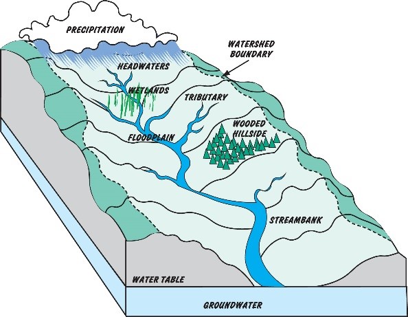
Diagram Credit: Wolf River Conservancy
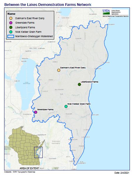
Manitowoc-Sheboygan Watershed
The Manitowoc-Sheboygan River Basin stretches from the north with the Twin and Branch Rivers originating in Brown, Kewaunee, and Manitowoc Counties, the west with the North and South Branches of the Manitowoc River, originating in Calumet County.
The watershed also stretches to the south with the Mullet, Onion, and Black Rivers originating in southern Sheyboygan and northern Ozaukee Counties. The Basin also includes the other tributaries of Lake Michigan, which of course, includes the Sheboygan River running through the City of Sheboygan.
The Problem
Surface waters in the Manitowoc-Sheboygan Watershed are impaired by excessive phosphorus and sediment loading. These impairments adversely affect fish and aquatic life, drinking water supplies, recreation, and potentially navigation.
(WI DNR – Northeast Lakeshore TMDL)
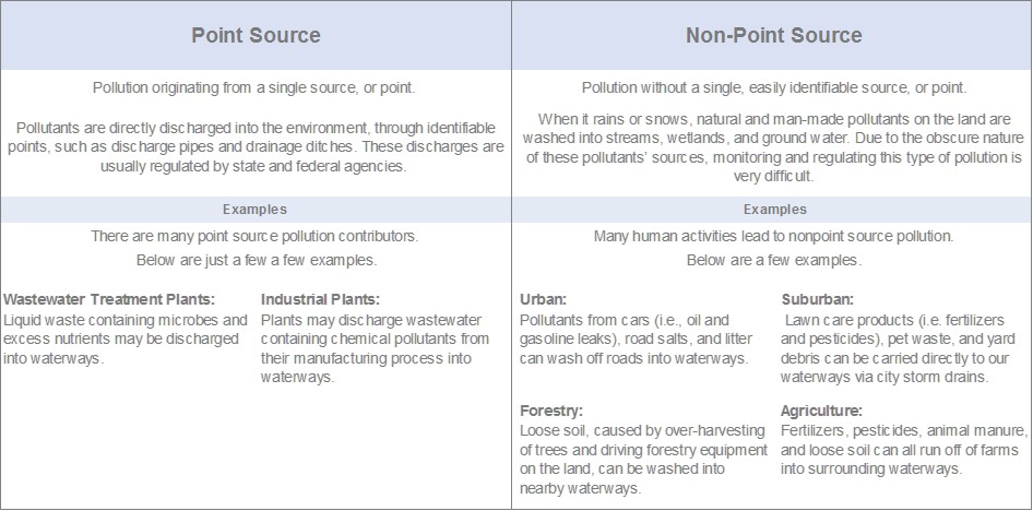
How Water Pollution Happens
Water Quality Standards
and Guiding Legislation
“Water quality” is a complex and dynamic term that is influenced by a wide range of factors. However, it is important to recognize that water health is influenced by different types of pollution from various sources.
Water Quality Standards
- The Federal Clean Water Act of 1972, dictates that states adopt water quality standards to protect, maintain and improve the quality of our nation’s surface waters.
- States identify waters within their boundaries that are not meeting those state water quality standards.
- Learn more about Wisconsin’s Water Quality Standards
Total Maximum Daily Load
- Defines the loading capacity, or the maximum amount of the pollutant that a waterbody can contain while continuing to meet water quality standards.
- Allocates the maximum allowable pollutant load incorporating both point and nonpoint sources of pollutants.
- Provides a framework for the Environmental Protection Agency (EPA), states, and partner organizations to establish and implement pollution control and management plans.
- (US EPA – Impaired Waters and TMDLs)
Northeast Lakeshore TMDL Development
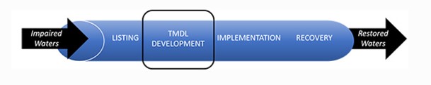
The Northeast Lakeshore TMDL is currently in the development stage.
Image Credit: Wisconsin Department of Natural Resources.
Between the Lakes Demonstration Farm Network and the Manitowoc-Sheboygan Watershed are guided by the Northeast Lakeshore TMDL. This TMDL is in development, so studies are being conducted to further understand surface water quality impairments from phosphorus, total suspended solids, and nonpoint nitrogen loading.
Once the studies are complete, a TMDL will be written. This plan will need to be approved by the Environmental Protection Agency. Upon approval, this TMDL will “provide a strategic framework and prioritize resources for surface water quality improvement across the basins that make up Wisconsin’s northeast lakeshore,” according to the Wisconsin Department of Natural Resources. At that point, we’ll be able to develop even more targeted strategies to help improve our waterways.
Want to Learn More?
The Between the Lakes Demonstration Farm Network is working to clean-up Wisconsin’s waterways. Explore the Non-Point Source Pollution our Network is addressing.